
This task is dealing with the assessment of the potential of the CLMS products and the enhanced LCLU database, available in the form of web application for supporting agricultural policy in Poland (under the CAP) and national agricultural policy in Norway.
Coordinated by the Norwegian Institute of Bioeconomy Research (NIBIO).
Specific Tasks:
Task 4.1: HRL Water and wetness (HRL-WAW)
Task 4.2: HRL Small Woody Features (HRL-SWF)
Task 4.3: HRL Imperviousness (HRL-IMD)
In Task 4.1 we compered the Copernicus HRL-WAW layer to data from field inventories and aerial image interpretation in order to determine the fitness for monitoring status and change. The methods included photogrammetry, remote sensing, spatial analysis and statistics as well as document analysis needed to understand the specific monitoring requirements.
The first deliverable: Report containing information on the potential, accuracy (thematic and geometric) of Copernicus HRL-WAW for assessment of agricultural landscapes and Ecological Focus Areas has been finalised.
The results of the analyses were presented at IALE 2022 – European Landscape Ecology Congress in the form of a presentation “Quality control of Copernicus High Resolution Layers for monitoring agricultural landscapes and wetlands”.

Overview of the HRL-WAW data for Poland (left) and Norway (right).
In Task 4.2 we carried out the analysis of the usefulness of Copernicus Small Woody Features product for assessment of woody elements in the agricultural landscape. The clusters and lines of trees and bushes observed in HRL-SWF were compared to data from field inventories and aerial photo interpretation to determinate suitability for use.
At the XXXI Polish Association for Spatial Information in 2022, the results of the analyses were presented in the presentation “Evaluation of the potential of Copernicus products: Riparian Zones and Small Woody Features for monitoring vegetation condition along streams and rivers in Poland “.
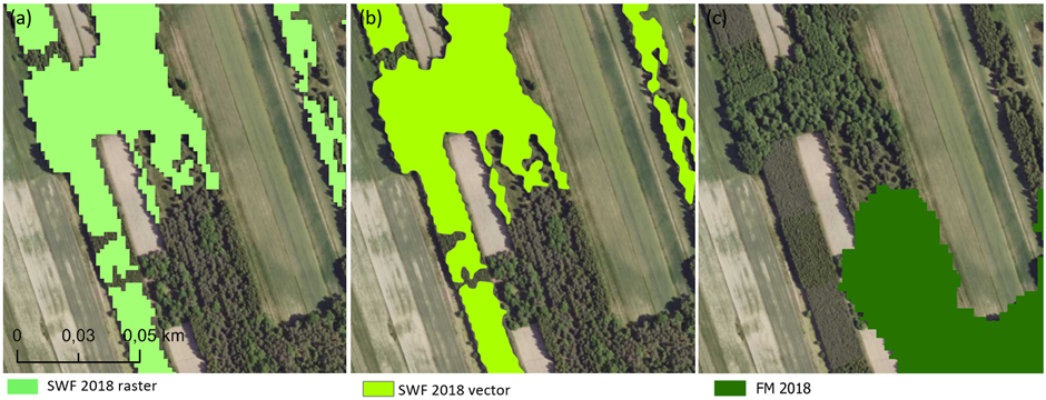
Overview of the HRL-SWF data for Poland
Ongoing activities:
We are starting the analysis of the High Resolution Layer Imperviousness Density (HRL IMD) to assess soil sealing in agricultural areas in Poland and Norway. The data observed in HRL IMD will be verified by random sampling method using VHR-satellite imagery and aerial photos.