About InCoNaDa

The project InCoNaDa “Enhancing the user uptake of Land Cover / Land Use information derived from the integration of Copernicus services and national databases” is funded by the Norway Grants via the National Centre for Research and Development’, programme ‘Applied Research’, the POLNOR 2019 Call. The project is co-funded in 15% from the targeted subsidies.   

Project duration: 1.10.2020 – 30.04.2024

Aim and Objectives

Assessment and monitoring of natural resources requires detailed, and up-to-date geospatial information on land cover (LC), land use (LU) and their changes over time. The LCLU information is essential for a broad range of users and applications. It is crucial for land management, monitoring of sustainable development of agriculture, forestry, rural areas, assessment of biodiversity status and losses, urban planning and land uptake. LCLU is also essential for various reporting obligations, for example, for counting greenhouse gas (GHG) emissions and removal from the Land Use, Land Use Change and Forestry (LULUCF) sector, a long-term climate mitigation, greening of Common Agricultural Policy (CAP), Biodiversity Conservation, Urban Agenda and plans for the upcoming Energy Union. Each of these regulations requires different level of details on land cover, land use and changes. The products of the Copernicus Land Monitoring Service are to some extent used in national research projects, but rarely in national mapping, reporting and monitoring programs carried out by national and regional authorities.

The main goal of InCoNaDa is to improve the user uptake of land cover and land use information derived from the integration of Copernicus Land Monitoring Services (CLMS) and national databases.
The proposed project will address the request for more detailed information on LCLU and its changes (in respect to spatial, temporal and thematic content), than is currently provided in Corine Land Cover (CLC) databases. Furthermore, the assessment of usefulness of enhanced LCLU database and CLMS products for decision makers, reporting obligations in natural resources monitoring, urban and spatial planning, agricultural management and reporting greenhouse gases emissions and removals from LULUCF in Poland and Norway.

The proposed project will address the following objectives:
1) to determine the most accurate land cover map based on a time series of Sentinel-2 data
using machine learning approaches;
2) to verify the EAGLE concept by developing and testing an approach for integration and population of land use information and delivering the enhanced LCLU database;
3) to design and develop web-based application enabling to query the enhanced LCLU database as well as to integrate and extract statistics from the CLMS adjusted to the user needs;
4) to proof if and how enhanced LCLU database and CLMS can be used in spatial planning;
5) to proof if and how the enhanced LCLU database and CLMS can be used in the agricultural management and environmental monitoring;
6) to demonstrate the usefulness of the enhanced LCLU database and CLMS for reporting GHG emissions and removals from LULUCF.

Study area

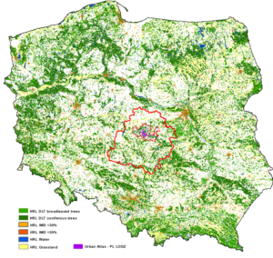
In Poland, the Łódź Province is selected for the detailed LCLU analysis. This province is located in central Poland. The capital of the province Łodź is the second biggest city in Poland, after Warsaw. Łodź together with neighbouring cities creates an agglomeration with nearly 1 million inhabitants. The region has agricultural and industrial character. The region is very dynamics, many investments and changes occur within the city and on the outskirts. In January 2019, the city of Łódź was awarded with the main price for the “Dynamically Developing City – Poland”.

*Study areas in Poland – Łódź Voivodship (bold red polygon); light red inside the Łódź Voivodship indicates the Urban Atlas for the city of Łódź *

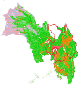
In Norway, the Viken county is selected. It includes the capital Oslo (administratively separate from Viken). Oslo is a city comparable to Lódź and the region has several other large cities, substantial amounts of agricultural land and forest. The northwestern part of the Viken county is reaching into the central mountain range. Viken thus represents considerable variation representative of much of Norway, but is also sufficiently large urban and agricultural areas to be reasonably comparable to the Lódź region.

*Study areas in Norway – Viken county Norway with Urban Atlas Oslo as bold red line.* 

Comments are closed.